Introduction
Tracking logistics and services with technology is a crucial service provided by many companies to their customers, from food deliveries, to international couriers. This service relies on geospatial technology, which combines location information, such as individual coordinates, and attribution information, i.e. details about the object. It may also provide information regarding the timing of movements of people or objects. (What Is Geospatial Data? | IBM, n.d.). As the applications of geospatial technology expand into areas spanning urban planning to social welfare delivery, it is important to see how this tool can facilitate more informed policy making.
Geospatial technology’s roots trace back to 1854 when John Snow attempted to map the spread of Cholera in London (GISGeography, 2024). By plotting the location of patients, he discovered that many were near water pumps, questioning the assumption that cholera was an airborne disease. This mapping instead revealed that cholera was a waterborne disease and is likely the first documented instance of the use of geospatial analysis.
Figure 1: An Illustration of John Snow’s Map Tracing the Spread of Cholera
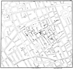
(Image source: GISGeography)
What is Geospatial Technology?
Geospatial data may be defined as ‘‘an information technology field of practice that acquires, manages, interprets, integrates, displays, analyses, or otherwise uses data focusing on the geographic, temporal, and spatial context,’’(Klinkenberg, 2007). Since 1854, geospatial technologies have evolved and a range of systems to collect as well as interpret geospatial data have been developed. The list of systems which can serve as geospatial technology is not exhaustive, given that this technology encompasses all systems which capture, present, and analyse such geospatial data. This could include software systems such as Geographical Information Systems (GIS), or physical devices such as satellites, or CCTV cameras. These data may be static or dynamic, like the GPS.
Geospatial Technology for Public Service Delivery
Geospatial technology’s uses have expanded to a host of services, from location tracking in planes, to efficiently delivering social benefits. For example, the Ministry of Rural Development, in partnership with IIT Delhi, recently introduced the ‘BhuPRAHARI’ initiative (PIB, 2024). This initiative aims to use ground and space-based geospatial technologies, along with artificial intelligence, to monitor and manage assets under the Mahatma Gandhi National Rural Employment Guarantee Act (MGNREGA), a rural employment guarantee scheme.
The primary reason cited for the use of geospatial technologies in MGNREGA, is the ability of geospatial technologies to increase transparency (Deccan Herald, 2024). There remains some ambiguity on how geospatial technologies would be integrated into the scheme, but there are some potential ways forward. A possible use case may involve monitoring the progress of projects at MGNREGA worksites using satellite imagery. The architects of the ‘BhuPRAHARI’ initiative contend that increased transparency in the execution of projects under MGNREGA will lead to an overall increase in efficiency of monitoring, the insights from which can facilitate better planning.
Not all interventions using this technology have been as successful as intended. For example, a similar initiative aimed at tracking MGNREGA worker attendance had limited success since workers found it inconvenient to walk back to a specific geotagged location at their worksite twice a day and has faced criticism from both workers and activists (Chitlangia, 2024). Critics argue that rural development authorities sometimes implement these technologies without considering significant barriers such as limited connectivity and the digital literacy of workers.
The use cases for geospatial technology are likely to expand in the future; it is therefore crucial to ensure that its implementation prioritises the needs of those most likely to be impacted. Adopting a user-centred approach will not only foreground the interests of users but also provide valuable insights for policymakers. As new categories of data are unlocked through the use of geospatial technologies, policymakers are likely to be better equipped to make informed policy decisions.
Banner image source: DALL – E